allmaps.de
Der Landkarten-Shop im Internet Deutschland Europa Welt
Startseite Kontakt
AGB Impressum


Der Einkaufskorb ist noch leer.


Deutschland: Amtliche Topographische Karten 1:25.000 nach Blattnummern (6000-6999)

Stöbern
<< Deutschland: Topographische Karten 1:25.000 im Regelblattschnitt nach Blattnummern
 

6002 Gemünd Topographische Karte 1:25.000 - Landesamt für Vermessung und Geobasisinformation Rheinland-Pfalz
ISBN 3896370642
Preis: EUR 5.00
Sofort lieferbar
6002 Gemünd - Wanderkarte mit Wanderwegen (geplottete Ausgabe) ProjektNord - Grundlage Amtliche topographische Karte Landesamt für Vermessung und Geobasisinformation Rheinland-Pfalz
Preis: EUR 19.90
Sofort lieferbar
6003 Mettendorf Topographische Karte 1:25.000 - Landesamt für Vermessung und Geobasisinformation Rheinland-Pfalz
ISBN 3896370650
Preis: EUR 5.00
Sofort lieferbar
6003 Mettendorf - Wanderkarte mit Wanderwegen (geplottete Ausgabe) ProjektNord - Grundlage Amtliche topographische Karte Landesamt für Vermessung und Geobasisinformation Rheinland-Pfalz
Preis: EUR 19.90
Sofort lieferbar
6004 Oberweis Topographische Karte 1:25.000 - Landesamt für Vermessung und Geobasisinformation Rheinland-Pfalz
ISBN 3896370669
Preis: EUR 5.00
Sofort lieferbar
6004 Oberweis - Wanderkarte mit Wanderwegen (geplottete Ausgabe) ProjektNord - Grundlage Amtliche topographische Karte Landesamt für Vermessung und Geobasisinformation Rheinland-Pfalz
Preis: EUR 19.90
Sofort lieferbar
6005 Bitburg Topographische Karte 1:25.000 - Landesamt für Vermessung und Geobasisinformation Rheinland-Pfalz
ISBN 3896370677
Preis: EUR 5.00
Sofort lieferbar
6005 Bitburg - Wanderkarte mit Wanderwegen (geplottete Ausgabe) ProjektNord - Grundlage Amtliche topographische Karte Landesamt für Vermessung und Geobasisinformation Rheinland-Pfalz
Preis: EUR 19.90
Sofort lieferbar
6006 Landscheid Topographische Karte 1:25.000 - Landesamt für Vermessung und Geobasisinformation Rheinland-Pfalz
ISBN 3896370685
Preis: EUR 5.00
Sofort lieferbar
6006 Landscheid - Wanderkarte mit Wanderwegen (geplottete Ausgabe) ProjektNord - Grundlage Amtliche topographische Karte Landesamt für Vermessung und Geobasisinformation Rheinland-Pfalz
Preis: EUR 19.90
Sofort lieferbar
6007 Wittlich Topographische Karte 1:25.000 - Landesamt für Vermessung und Geobasisinformation Rheinland-Pfalz
ISBN 3896370693
Preis: EUR 5.00
Sofort lieferbar
6007 Wittlich - Wanderkarte mit Wanderwegen (geplottete Ausgabe) ProjektNord - Grundlage Amtliche topographische Karte Landesamt für Vermessung und Geobasisinformation Rheinland-Pfalz
Preis: EUR 19.90
Sofort lieferbar
6008 Bernkastel-Kues Topographische Karte 1:25.000 - Landesamt für Vermessung und Geobasisinformation Rheinland-Pfalz
ISBN 3896370707
Preis: EUR 5.00
Sofort lieferbar
6008 Bernkastel-Kues - Wanderkarte mit Wanderwegen (geplottete Ausgabe) ProjektNord - Grundlage Amtliche topographische Karte Landesamt für Vermessung und Geobasisinformation Rheinland-Pfalz
Preis: EUR 19.90
Sofort lieferbar
6009 Sohren Topographische Karte 1:25.000 - Landesamt für Vermessung und Geobasisinformation Rheinland-Pfalz
ISBN 3896370715
Preis: EUR 5.00
Sofort lieferbar
6009 Sohren - Wanderkarte mit Wanderwegen (geplottete Ausgabe) ProjektNord - Grundlage Amtliche topographische Karte Landesamt für Vermessung und Geobasisinformation Rheinland-Pfalz
Preis: EUR 19.90
Sofort lieferbar
6010 Kirchberg (Hunsrück) Topographische Karte 1:25.000 - Landesamt für Vermessung und Geobasisinformation Rheinland-Pfalz
ISBN 3896370723
Preis: EUR 5.00
Sofort lieferbar
6010 Kirchberg (Hunsrück) - Wanderkarte mit Wanderwegen (geplottete Ausgabe) ProjektNord - Grundlage Amtliche topographische Karte Landesamt für Vermessung und Geobasisinformation Rheinland-Pfalz
Preis: EUR 19.90
Sofort lieferbar
6011 Simmern (Hunsrück) Topographische Karte 1:25.000 - Landesamt für Vermessung und Geobasisinformation Rheinland-Pfalz
ISBN 3896370731
Preis: EUR 5.00
Sofort lieferbar
6011 Simmern (Hunsrück) - Wanderkarte mit Wanderwegen (geplottete Ausgabe) ProjektNord - Grundlage Amtliche topographische Karte Landesamt für Vermessung und Geobasisinformation Rheinland-Pfalz
Preis: EUR 19.90
Sofort lieferbar
6012 Stromberg Topographische Karte 1:25.000 - Landesamt für Vermessung und Geobasisinformation Rheinland-Pfalz
ISBN 389637074X
Preis: EUR 5.00
Sofort lieferbar
6012 Stromberg - Wanderkarte mit Wanderwegen (geplottete Ausgabe) ProjektNord - Grundlage Amtliche topographische Karte Landesamt für Vermessung und Geobasisinformation Rheinland-Pfalz
Preis: EUR 19.90
Sofort lieferbar
6013 Bingen am Rhein Topographische Karte 1:25.000 - Landesamt für Vermessung und Geobasisinformation Rheinland-Pfalz
ISBN 3896370758
Preis: EUR 5.00
Sofort lieferbar
6013 Bingen am Rhein - Wanderkarte mit Wanderwegen (geplottete Ausgabe) ProjektNord - Grundlage Amtliche topographische Karte Landesamt für Vermessung und Geobasisinformation Rheinland-Pfalz
Preis: EUR 19.90
Sofort lieferbar
6014 Ingelheim am Rhein Topographische Karte 1:25.000 - Landesamt für Vermessung und Geobasisinformation Rheinland-Pfalz
ISBN 3896370766
Preis: EUR 5.00
Sofort lieferbar
6014 Ingelheim am Rhein - Wanderkarte mit Wanderwegen (geplottete Ausgabe) ProjektNord - Grundlage Amtliche topographische Karte Landesamt für Vermessung und Geobasisinformation Rheinland-Pfalz
Preis: EUR 19.90
Sofort lieferbar
6015 Mainz Topographische Karte 1:25.000 - Landesamt für Vermessung und Geobasisinformation Rheinland-Pfalz
ISBN 3896370774
Preis: EUR 5.00
Sofort lieferbar
6015 Mainz - Wanderkarte mit Wanderwegen (geplottete Ausgabe) ProjektNord - Grundlage Amtliche topographische Karte Landesamt für Vermessung und Geobasisinformation Rheinland-Pfalz
Preis: EUR 19.90
Sofort lieferbar
6016 Groß-Gerau Topographische Landkarte Hessen 1:25.000 - ProjektNord (geplottete Ausgabe)
Preis: EUR 17.90
Sofort lieferbar
6016 Groß-Gerau - Wanderkarte mit Wanderwegen (geplottete Ausgabe) Topographische Landkarte Hessen 1:25.000 - ProjektNord (geplottete Ausgabe)
Preis: EUR 19.90
Sofort lieferbar
6017 Mörfelden Topographische Landkarte Hessen 1:25.000 - ProjektNord (geplottete Ausgabe)
Preis: EUR 17.90
Sofort lieferbar
6017 Mörfelden - Wanderkarte mit Wanderwegen (geplottete Ausgabe) Topographische Landkarte Hessen 1:25.000 - ProjektNord (geplottete Ausgabe)
Preis: EUR 19.90
Sofort lieferbar
6018 Langen Topographische Landkarte Hessen 1:25.000 - ProjektNord (geplottete Ausgabe)
Preis: EUR 17.90
Sofort lieferbar
6018 Langen - Wanderkarte mit Wanderwegen (geplottete Ausgabe) Topographische Landkarte Hessen 1:25.000 - ProjektNord (geplottete Ausgabe)
Preis: EUR 19.90
Sofort lieferbar
6019 Babenhausen Topographische Landkarte Hessen 1:25.000 - ProjektNord (geplottete Ausgabe)
Preis: EUR 17.90
Sofort lieferbar
6019 Babenhausen - Wanderkarte mit Wanderwegen (geplottete Ausgabe) Topographische Landkarte Hessen 1:25.000 - ProjektNord (geplottete Ausgabe)
Preis: EUR 19.90
Sofort lieferbar
6025 Arnstein Topographische Landkarte Bayern 1:25.000 (Normalausgabe - Atkis) Landesvermessungsamt Bayern
ISBN 3860388282
Preis: EUR 6.20
Sofort lieferbar
6026 Werneck Topographische Landkarte Bayern 1:25.000 (Normalausgabe - Atkis) Landesvermessungsamt Bayern
ISBN 3860388290
Preis: EUR 6.20
Sofort lieferbar
6027 Grettstadt Topographische Landkarte Bayern 1:25.000 (Normalausgabe - Atkis) Landesvermessungsamt Bayern
ISBN 3860388304
Preis: EUR 6.20
Sofort lieferbar
6103 Wallendorf Topographische Karte 1:25.000 - Landesamt für Vermessung und Geobasisinformation Rheinland-Pfalz
ISBN 3896370782
Preis: EUR 5.00
Sofort lieferbar
6103 Wallendorf - Wanderkarte mit Wanderwegen (geplottete Ausgabe) ProjektNord - Grundlage Amtliche topographische Karte Landesamt für Vermessung und Geobasisinformation Rheinland-Pfalz
Preis: EUR 19.90
Sofort lieferbar
6104 Bollendorf Topographische Karte 1:25.000 - Landesamt für Vermessung und Geobasisinformation Rheinland-Pfalz
ISBN 3896370790
Preis: EUR 5.00
Sofort lieferbar
6104 Bollendorf - Wanderkarte mit Wanderwegen (geplottete Ausgabe) ProjektNord - Grundlage Amtliche topographische Karte Landesamt für Vermessung und Geobasisinformation Rheinland-Pfalz
Preis: EUR 19.90
Sofort lieferbar
6105 Welschbillig Topographische Karte 1:25.000 - Landesamt für Vermessung und Geobasisinformation Rheinland-Pfalz
ISBN 3896370804
Preis: EUR 5.00
Sofort lieferbar
6105 Welschbillig - Wanderkarte mit Wanderwegen (geplottete Ausgabe) ProjektNord - Grundlage Amtliche topographische Karte Landesamt für Vermessung und Geobasisinformation Rheinland-Pfalz
Preis: EUR 19.90
Sofort lieferbar
6106 Schweich Topographische Karte 1:25.000 - Landesamt für Vermessung und Geobasisinformation Rheinland-Pfalz
ISBN 3896370812
Preis: EUR 5.00
Sofort lieferbar
6106 Schweich - Wanderkarte mit Wanderwegen (geplottete Ausgabe) ProjektNord - Grundlage Amtliche topographische Karte Landesamt für Vermessung und Geobasisinformation Rheinland-Pfalz
Preis: EUR 19.90
Sofort lieferbar
6107 Neumagen-Dhron Topographische Karte 1:25.000 - Landesamt für Vermessung und Geobasisinformation Rheinland-Pfalz
ISBN 3896370820
Preis: EUR 5.00
Sofort lieferbar
6107 Neumagen-Dhron - Wanderkarte mit Wanderwegen (geplottete Ausgabe) ProjektNord - Grundlage Amtliche topographische Karte Landesamt für Vermessung und Geobasisinformation Rheinland-Pfalz
Preis: EUR 19.90
Sofort lieferbar
6108 Morbach Topographische Karte 1:25.000 - Landesamt für Vermessung und Geobasisinformation Rheinland-Pfalz
ISBN 3896370839
Preis: EUR 5.00
Sofort lieferbar
6108 Morbach - Wanderkarte mit Wanderwegen (geplottete Ausgabe) ProjektNord - Grundlage Amtliche topographische Karte Landesamt für Vermessung und Geobasisinformation Rheinland-Pfalz
Preis: EUR 19.90
Sofort lieferbar
6109 Hottenbach Topographische Karte 1:25.000 - Landesamt für Vermessung und Geobasisinformation Rheinland-Pfalz
ISBN 3896370847
Preis: EUR 5.00
Sofort lieferbar
6109 Hottenbach - Wanderkarte mit Wanderwegen (geplottete Ausgabe) ProjektNord - Grundlage Amtliche topographische Karte Landesamt für Vermessung und Geobasisinformation Rheinland-Pfalz
Preis: EUR 19.90
Sofort lieferbar
6110 Gemünden Topographische Karte 1:25.000 - Landesamt für Vermessung und Geobasisinformation Rheinland-Pfalz
ISBN 3896370855
Preis: EUR 5.00
Sofort lieferbar
6110 Gemünden - Wanderkarte mit Wanderwegen (geplottete Ausgabe) ProjektNord - Grundlage Amtliche topographische Karte Landesamt für Vermessung und Geobasisinformation Rheinland-Pfalz
Preis: EUR 19.90
Sofort lieferbar
6111 Pferdsfeld Topographische Karte 1:25.000 - Landesamt für Vermessung und Geobasisinformation Rheinland-Pfalz
ISBN 3896370863
Preis: EUR 5.00
Sofort lieferbar
6111 Pferdsfeld - Wanderkarte mit Wanderwegen (geplottete Ausgabe) ProjektNord - Grundlage Amtliche topographische Karte Landesamt für Vermessung und Geobasisinformation Rheinland-Pfalz
Preis: EUR 19.90
Sofort lieferbar
6112 Waldböckelheim Topographische Karte 1:25.000 - Landesamt für Vermessung und Geobasisinformation Rheinland-Pfalz
ISBN 3896370871
Preis: EUR 5.00
Sofort lieferbar
6112 Waldböckelheim - Wanderkarte mit Wanderwegen (geplottete Ausgabe) ProjektNord - Grundlage Amtliche topographische Karte Landesamt für Vermessung und Geobasisinformation Rheinland-Pfalz
Preis: EUR 19.90
Sofort lieferbar
6113 Bad Kreuznach Topographische Karte 1:25.000 - Landesamt für Vermessung und Geobasisinformation Rheinland-Pfalz
ISBN 389637088X
Preis: EUR 5.00
Sofort lieferbar
6113 Bad Kreuznach - Wanderkarte mit Wanderwegen (geplottete Ausgabe) ProjektNord - Grundlage Amtliche topographische Karte Landesamt für Vermessung und Geobasisinformation Rheinland-Pfalz
Preis: EUR 19.90
Sofort lieferbar
6114 Wörrstadt Topographische Karte 1:25.000 - Landesamt für Vermessung und Geobasisinformation Rheinland-Pfalz
ISBN 3896370898
Preis: EUR 5.00
Sofort lieferbar
6114 Wörrstadt - Wanderkarte mit Wanderwegen (geplottete Ausgabe) ProjektNord - Grundlage Amtliche topographische Karte Landesamt für Vermessung und Geobasisinformation Rheinland-Pfalz
Preis: EUR 19.90
Sofort lieferbar
6115 Undenheim Topographische Karte 1:25.000 - Landesamt für Vermessung und Geobasisinformation Rheinland-Pfalz
ISBN 3896370901
Preis: EUR 5.00
Sofort lieferbar
6115 Undenheim - Wanderkarte mit Wanderwegen (geplottete Ausgabe) ProjektNord - Grundlage Amtliche topographische Karte Landesamt für Vermessung und Geobasisinformation Rheinland-Pfalz
Preis: EUR 19.90
Sofort lieferbar
6116 Oppenheim Topographische Landkarte Hessen 1:25.000 - ProjektNord (geplottete Ausgabe)
Preis: EUR 17.90
Sofort lieferbar
6116 Oppenheim - Wanderkarte mit Wanderwegen (geplottete Ausgabe) Topographische Landkarte Hessen 1:25.000 - ProjektNord (geplottete Ausgabe)
Preis: EUR 19.90
Sofort lieferbar
6117 Darmstadt West Topographische Landkarte Hessen 1:25.000 - ProjektNord (geplottete Ausgabe)
Preis: EUR 17.90
Sofort lieferbar
6117 Darmstadt West - Wanderkarte mit Wanderwegen (geplottete Ausgabe) Topographische Landkarte Hessen 1:25.000 - ProjektNord (geplottete Ausgabe)
Preis: EUR 19.90
Sofort lieferbar
6118 Darmstadt Ost Topographische Landkarte Hessen 1:25.000 - ProjektNord (geplottete Ausgabe)
Preis: EUR 17.90
Sofort lieferbar
6118 Darmstadt Ost - Wanderkarte mit Wanderwegen (geplottete Ausgabe) Topographische Landkarte Hessen 1:25.000 - ProjektNord (geplottete Ausgabe)
Preis: EUR 19.90
Sofort lieferbar
6119 Groß-Umstadt Topographische Landkarte Hessen 1:25.000 - ProjektNord (geplottete Ausgabe)
Preis: EUR 17.90
Sofort lieferbar
6119 Groß-Umstadt - Wanderkarte mit Wanderwegen (geplottete Ausgabe) Topographische Landkarte Hessen 1:25.000 - ProjektNord (geplottete Ausgabe)
Preis: EUR 19.90
Sofort lieferbar
6126 Dettelbach Topographische Landkarte Bayern 1:25.000 (Normalausgabe - Atkis) Landesvermessungsamt Bayern
ISBN 3860388436
Preis: EUR 6.20
Sofort lieferbar
6140 Tirschenreuth Topographische Landkarte Bayern 1:25.000 Landesvermessungsamt Bayern
ISBN 3860387545
Preis: EUR 6.20
Sofort lieferbar
6204 Langsur Topographische Karte 1:25.000 - Landesamt für Vermessung und Geobasisinformation Rheinland-Pfalz
ISBN 389637091X
Preis: EUR 5.00
Sofort lieferbar
6204 Langsur - Wanderkarte mit Wanderwegen (geplottete Ausgabe) ProjektNord - Grundlage Amtliche topographische Karte Landesamt für Vermessung und Geobasisinformation Rheinland-Pfalz
Preis: EUR 19.90
Sofort lieferbar
6205 Trier Topographische Karte 1:25.000 - Landesamt für Vermessung und Geobasisinformation Rheinland-Pfalz
ISBN 3896370928
Preis: EUR 5.00
Sofort lieferbar
6205 Trier ERSATZAUSGABE (erhöhter Preis!) Topographische Karte 1:25.000 - Plot aus den amtlichen topographischen Karten der Landesvermessungsämter ProjektNord
Preis: EUR 17.90
Sofort lieferbar
6205 Trier - Wanderkarte mit Wanderwegen (geplottete Ausgabe) ProjektNord - Grundlage Amtliche topographische Karte Landesamt für Vermessung und Geobasisinformation Rheinland-Pfalz
Preis: EUR 19.90
Sofort lieferbar
6206 Trier-Pfalzel Topographische Karte 1:25.000 - Landesamt für Vermessung und Geobasisinformation Rheinland-Pfalz
ISBN 3896370936
Preis: EUR 5.00
Sofort lieferbar
6206 Trier-Pfalzel - Wanderkarte mit Wanderwegen (geplottete Ausgabe) ProjektNord - Grundlage Amtliche topographische Karte Landesamt für Vermessung und Geobasisinformation Rheinland-Pfalz
Preis: EUR 19.90
Sofort lieferbar
6207 Beuren (Hochwald) Topographische Karte 1:25.000 - Landesamt für Vermessung und Geobasisinformation Rheinland-Pfalz
ISBN 3896370944
Preis: EUR 5.00
Sofort lieferbar
6207 Beuren (Hochwald) - Wanderkarte mit Wanderwegen (geplottete Ausgabe) ProjektNord - Grundlage Amtliche topographische Karte Landesamt für Vermessung und Geobasisinformation Rheinland-Pfalz
Preis: EUR 19.90
Sofort lieferbar
6208 Morscheid-Riedenburg Topographische Karte 1:25.000 - Landesamt für Vermessung und Geobasisinformation Rheinland-Pfalz
ISBN 3896370952
Preis: EUR 5.00
Sofort lieferbar
6208 Morscheid-Riedenburg - Wanderkarte mit Wanderwegen (geplottete Ausgabe) ProjektNord - Grundlage Amtliche topographische Karte Landesamt für Vermessung und Geobasisinformation Rheinland-Pfalz
Preis: EUR 19.90
Sofort lieferbar
6209 Idar-Oberstein Topographische Karte 1:25.000 - Landesamt für Vermessung und Geobasisinformation Rheinland-Pfalz
ISBN 3896370960
Preis: EUR 5.00
Sofort lieferbar
6209 Idar-Oberstein - Wanderkarte mit Wanderwegen (geplottete Ausgabe) ProjektNord - Grundlage Amtliche topographische Karte Landesamt für Vermessung und Geobasisinformation Rheinland-Pfalz
Preis: EUR 19.90
Sofort lieferbar
6210 Kirn Topographische Karte 1:25.000 - Landesamt für Vermessung und Geobasisinformation Rheinland-Pfalz
ISBN 3896370979
Preis: EUR 5.00
Sofort lieferbar
6210 Kirn - Wanderkarte mit Wanderwegen (geplottete Ausgabe) ProjektNord - Grundlage Amtliche topographische Karte Landesamt für Vermessung und Geobasisinformation Rheinland-Pfalz
Preis: EUR 19.90
Sofort lieferbar
6211 Bad Sobernheim Topographische Karte 1:25.000 - Landesamt für Vermessung und Geobasisinformation Rheinland-Pfalz
ISBN 3896370987
Preis: EUR 5.00
Sofort lieferbar
6211 Bad Sobernheim - Wanderkarte mit Wanderwegen (geplottete Ausgabe) ProjektNord - Grundlage Amtliche topographische Karte Landesamt für Vermessung und Geobasisinformation Rheinland-Pfalz
Preis: EUR 19.90
Sofort lieferbar
6212 Meisenheim Topographische Karte 1:25.000 - Landesamt für Vermessung und Geobasisinformation Rheinland-Pfalz
ISBN 3896370995
Preis: EUR 5.00
Sofort lieferbar
6212 Meisenheim - Wanderkarte mit Wanderwegen (geplottete Ausgabe) ProjektNord - Grundlage Amtliche topographische Karte Landesamt für Vermessung und Geobasisinformation Rheinland-Pfalz
Preis: EUR 19.90
Sofort lieferbar
6213 Kriegsfeld Topographische Karte 1:25.000 - Landesamt für Vermessung und Geobasisinformation Rheinland-Pfalz
ISBN 3896371002
Preis: EUR 5.00
Sofort lieferbar
6213 Kriegsfeld - Wanderkarte mit Wanderwegen (geplottete Ausgabe) ProjektNord - Grundlage Amtliche topographische Karte Landesamt für Vermessung und Geobasisinformation Rheinland-Pfalz
Preis: EUR 19.90
Sofort lieferbar
6214 Alzey Topographische Karte 1:25.000 - Landesamt für Vermessung und Geobasisinformation Rheinland-Pfalz
ISBN 3896371010
Preis: EUR 5.00
Sofort lieferbar
6214 Alzey - Wanderkarte mit Wanderwegen (geplottete Ausgabe) ProjektNord - Grundlage Amtliche topographische Karte Landesamt für Vermessung und Geobasisinformation Rheinland-Pfalz
Preis: EUR 19.90
Sofort lieferbar
6215 Gau-Odernheim Topographische Karte 1:25.000 - Landesamt für Vermessung und Geobasisinformation Rheinland-Pfalz
ISBN 3896371029
Preis: EUR 5.00
Sofort lieferbar
6215 Gau-Odernheim - Wanderkarte mit Wanderwegen (geplottete Ausgabe) ProjektNord - Grundlage Amtliche topographische Karte Landesamt für Vermessung und Geobasisinformation Rheinland-Pfalz
Preis: EUR 19.90
Sofort lieferbar
6216 Gernsheim Topographische Landkarte Hessen 1:25.000 - ProjektNord (geplottete Ausgabe)
Preis: EUR 17.90
Sofort lieferbar
6216 Gernsheim - Wanderkarte mit Wanderwegen (geplottete Ausgabe) Topographische Landkarte Hessen 1:25.000 - ProjektNord (geplottete Ausgabe)
Preis: EUR 19.90
Sofort lieferbar
6217 Zwingenberg Topographische Landkarte Hessen 1:25.000 - ProjektNord (geplottete Ausgabe)
Preis: EUR 17.90
Sofort lieferbar
6217 Zwingenberg - Wanderkarte mit Wanderwegen (geplottete Ausgabe) Topographische Landkarte Hessen 1:25.000 - ProjektNord (geplottete Ausgabe)
Preis: EUR 19.90
Sofort lieferbar
6218 Neunkirchen Topographische Landkarte Hessen 1:25.000 - ProjektNord (geplottete Ausgabe)
Preis: EUR 17.90
Sofort lieferbar
6218 Neunkirchen - Wanderkarte mit Wanderwegen (geplottete Ausgabe) Topographische Landkarte Hessen 1:25.000 - ProjektNord (geplottete Ausgabe)
Preis: EUR 19.90
Sofort lieferbar
6219 Brensbach Topographische Landkarte Hessen 1:25.000 - ProjektNord (geplottete Ausgabe)
Preis: EUR 17.90
Sofort lieferbar
6219 Brensbach - Wanderkarte mit Wanderwegen (geplottete Ausgabe) Topographische Landkarte Hessen 1:25.000 - ProjektNord (geplottete Ausgabe)
Preis: EUR 19.90
Sofort lieferbar
6220 Wörth Topographische Landkarte Hessen 1:25.000 - ProjektNord (geplottete Ausgabe)
Preis: EUR 17.90
Sofort lieferbar
6220 Wörth - Wanderkarte mit Wanderwegen (geplottete Ausgabe) Topographische Landkarte Hessen 1:25.000 - ProjektNord (geplottete Ausgabe)
Preis: EUR 19.90
Sofort lieferbar
6223 Wertheim Topographische Landkarte 1:25.000 - Landesvermessungsamt Baden-Württemberg
ISBN 3863980018
Preis: EUR 5.40
Sofort lieferbar
6227 Iphofen - mit Wanderwegen Topographische Landkarte Bayern 1:25.000 - Landesamt für Vermessung und Geobasisinformation Bayern
ISBN 386038855X
Preis: EUR 6.20
Sofort lieferbar
6304 Wincheringen Topographische Karte 1:25.000 - Landesamt für Vermessung und Geobasisinformation Rheinland-Pfalz
ISBN 3896371037
Preis: EUR 5.00
Sofort lieferbar
6304 Wincheringen - Wanderkarte mit Wanderwegen (geplottete Ausgabe) ProjektNord - Grundlage Amtliche topographische Karte Landesamt für Vermessung und Geobasisinformation Rheinland-Pfalz
Preis: EUR 19.90
Sofort lieferbar
6305 Saarburg Topographische Karte 1:25.000 - Landesamt für Vermessung und Geobasisinformation Rheinland-Pfalz
ISBN 3896371045
Preis: EUR 5.00
Sofort lieferbar
6305 Saarburg - Wanderkarte mit Wanderwegen (geplottete Ausgabe) ProjektNord - Grundlage Amtliche topographische Karte Landesamt für Vermessung und Geobasisinformation Rheinland-Pfalz
Preis: EUR 19.90
Sofort lieferbar
6306 Kell am See Topographische Karte 1:25.000 - Landesamt für Vermessung und Geobasisinformation Rheinland-Pfalz
ISBN 3896371053
Preis: EUR 5.00
Sofort lieferbar
6306 Kell am See ERSATZAUSGABE (erhöhter Preis!) Topographische Karte 1:25.000 - Plot aus den amtlichen topographischen Karten der Landesvermessungsämter ProjektNord
Preis: EUR 17.90
Sofort lieferbar
6306 Kell am See - Wanderkarte mit Wanderwegen (geplottete Ausgabe) ProjektNord - Grundlage Amtliche topographische Karte Landesamt für Vermessung und Geobasisinformation Rheinland-Pfalz
Preis: EUR 19.90
Sofort lieferbar
6307 Hermeskeil Topographische Karte 1:25.000 - Landesamt für Vermessung und Geobasisinformation Rheinland-Pfalz
ISBN 3896371061
Preis: EUR 5.00
Sofort lieferbar
6307 Hermeskeil ERSATZAUSGABE (erhöhter Preis!) Topographische Karte 1:25.000 - Plot aus den amtlichen topographischen Karten der Landesvermessungsämter ProjektNord
Preis: EUR 17.90
Sofort lieferbar
6308 Birkenfeld West Topographische Karte 1:25.000 - Landesamt für Vermessung und Geobasisinformation Rheinland-Pfalz
ISBN 389637107X
Preis: EUR 5.00
Sofort lieferbar
6309 Birkenfeld Ost Topographische Karte 1:25.000 - Landesamt für Vermessung und Geobasisinformation Rheinland-Pfalz
ISBN 3896371088
Preis: EUR 5.00
Sofort lieferbar
6309 Birkenfeld Ost - Wanderkarte mit Wanderwegen (geplottete Ausgabe) ProjektNord - Grundlage Amtliche topographische Karte Landesamt für Vermessung und Geobasisinformation Rheinland-Pfalz
Preis: EUR 19.90
Sofort lieferbar
6310 Baumholder Topographische Karte 1:25.000 - Landesamt für Vermessung und Geobasisinformation Rheinland-Pfalz
ISBN 3896371096
Preis: EUR 5.00
Sofort lieferbar
6310 Baumholder - Wanderkarte mit Wanderwegen (geplottete Ausgabe) ProjektNord - Grundlage Amtliche topographische Karte Landesamt für Vermessung und Geobasisinformation Rheinland-Pfalz
Preis: EUR 19.90
Sofort lieferbar
6311 Lauterecken Topographische Karte 1:25.000 - Landesamt für Vermessung und Geobasisinformation Rheinland-Pfalz
ISBN 389637110X
Preis: EUR 5.00
Sofort lieferbar
6311 Lauterecken - Wanderkarte mit Wanderwegen (geplottete Ausgabe) ProjektNord - Grundlage Amtliche topographische Karte Landesamt für Vermessung und Geobasisinformation Rheinland-Pfalz
Preis: EUR 19.90
Sofort lieferbar
6312 Rockenhausen Topographische Karte 1:25.000 - Landesamt für Vermessung und Geobasisinformation Rheinland-Pfalz
ISBN 3896371118
Preis: EUR 5.00
Sofort lieferbar
6312 Rockenhausen - Wanderkarte mit Wanderwegen (geplottete Ausgabe) ProjektNord - Grundlage Amtliche topographische Karte Landesamt für Vermessung und Geobasisinformation Rheinland-Pfalz
Preis: EUR 19.90
Sofort lieferbar
6313 Dannenfels Topographische Karte 1:25.000 - Landesamt für Vermessung und Geobasisinformation Rheinland-Pfalz
ISBN 3896371126
Preis: EUR 5.00
Sofort lieferbar
6313 Dannenfels - Wanderkarte mit Wanderwegen (geplottete Ausgabe) ProjektNord - Grundlage Amtliche topographische Karte Landesamt für Vermessung und Geobasisinformation Rheinland-Pfalz
Preis: EUR 19.90
Sofort lieferbar
6314 Kirchheimbolanden Topographische Karte 1:25.000 - Landesamt für Vermessung und Geobasisinformation Rheinland-Pfalz
ISBN 3896371134
Preis: EUR 5.00
Sofort lieferbar
6314 Kirchheimbolanden - Wanderkarte mit Wanderwegen (geplottete Ausgabe) ProjektNord - Grundlage Amtliche topographische Karte Landesamt für Vermessung und Geobasisinformation Rheinland-Pfalz
Preis: EUR 19.90
Sofort lieferbar
6315 Worms-Pfeddersheim Topographische Karte 1:25.000 - Landesamt für Vermessung und Geobasisinformation Rheinland-Pfalz
ISBN 3896371142
Preis: EUR 5.00
Sofort lieferbar
6315 Worms-Pfeddersheim - Wanderkarte mit Wanderwegen (geplottete Ausgabe) ProjektNord - Grundlage Amtliche topographische Karte Landesamt für Vermessung und Geobasisinformation Rheinland-Pfalz
Preis: EUR 19.90
Sofort lieferbar
6316 Worms Topographische Landkarte Hessen 1:25.000 - ProjektNord (geplottete Ausgabe)
Preis: EUR 17.90
Sofort lieferbar
6316 Worms - Wanderkarte mit Wanderwegen (geplottete Ausgabe) Topographische Landkarte Hessen 1:25.000 - ProjektNord (geplottete Ausgabe)
Preis: EUR 19.90
Sofort lieferbar
6317 Bensheim Topographische Landkarte Hessen 1:25.000 - ProjektNord (geplottete Ausgabe)
Preis: EUR 17.90
Sofort lieferbar
6317 Bensheim - Wanderkarte mit Wanderwegen (geplottete Ausgabe) Topographische Landkarte Hessen 1:25.000 - ProjektNord (geplottete Ausgabe)
Preis: EUR 19.90
Sofort lieferbar
6318 Lindenfels Topographische Landkarte Hessen 1:25.000 - ProjektNord (geplottete Ausgabe)
Preis: EUR 17.90
Sofort lieferbar
6318 Lindenfels - Wanderkarte mit Wanderwegen (geplottete Ausgabe) Topographische Landkarte Hessen 1:25.000 - ProjektNord (geplottete Ausgabe)
Preis: EUR 19.90
Sofort lieferbar
6319 Erbach Topographische Landkarte Hessen 1:25.000 - ProjektNord (geplottete Ausgabe)
Preis: EUR 17.90
Sofort lieferbar
6319 Erbach - Wanderkarte mit Wanderwegen (geplottete Ausgabe) Topographische Landkarte Hessen 1:25.000 - ProjektNord (geplottete Ausgabe)
Preis: EUR 19.90
Sofort lieferbar
6320 Michelstadt Topographische Landkarte Hessen 1:25.000 - ProjektNord (geplottete Ausgabe)
Preis: EUR 17.90
Sofort lieferbar
6320 Michelstadt - Wanderkarte mit Wanderwegen (geplottete Ausgabe) Topographische Landkarte Hessen 1:25.000 - ProjektNord (geplottete Ausgabe)
Preis: EUR 19.90
Sofort lieferbar
6404 Kirf Topographische Karte 1:25.000 - Landesamt für Vermessung und Geobasisinformation Rheinland-Pfalz
ISBN 3896371150
Preis: EUR 5.00
Sofort lieferbar
6405 Freudenburg Topographische Karte 1:25.000 - Landesamt für Vermessung und Geobasisinformation Rheinland-Pfalz
ISBN 3896371169
Preis: EUR 5.00
Sofort lieferbar
6405 Freudenburg ERSATZAUSGABE (erhöhter Preis!) Topographische Karte 1:25.000 - Plot aus den amtlichen topographischen Karten der Landesvermessungsämter ProjektNord
Preis: EUR 17.90
Sofort lieferbar
6406 Losheim Topographische Karte 1:25.000 - Landesvermessungsamt Saarland
ISBN 3935804008
Preis: EUR 8.20
Sofort lieferbar
6407 Wadern (Normalausgabe mit UTM-Koordinaten) Topographische Karte 1:25.000 - Landesvermessungsamt Saarland
ISBN 3935804016
Preis: EUR 8.20
Sofort lieferbar
6408 Nohfelden Topographische Karte 1:25.000 - Landesvermessungsamt Saarland
ISBN 3935804024
Preis: EUR 8.20
Sofort lieferbar
6409 Freisen (Normalausgabe mit UTM-Koordinaten) Topographische Karte 1:25.000 - Landesvermessungsamt Saarland
ISBN 3935804032
Preis: EUR 8.20
Sofort lieferbar
6410 Kusel Topographische Karte 1:25.000 - Landesamt für Vermessung und Geobasisinformation Rheinland-Pfalz
ISBN 3896371177
Preis: EUR 5.00
Sofort lieferbar
6410 Kusel - Wanderkarte mit Wanderwegen (geplottete Ausgabe) ProjektNord - Grundlage Amtliche topographische Karte Landesamt für Vermessung und Geobasisinformation Rheinland-Pfalz
Preis: EUR 19.90
Sofort lieferbar
6411 Wolfstein Topographische Karte 1:25.000 - Landesamt für Vermessung und Geobasisinformation Rheinland-Pfalz
ISBN 3896371185
Preis: EUR 5.00
Sofort lieferbar
6411 Wolfstein - Wanderkarte mit Wanderwegen (geplottete Ausgabe) ProjektNord - Grundlage Amtliche topographische Karte Landesamt für Vermessung und Geobasisinformation Rheinland-Pfalz
Preis: EUR 19.90
Sofort lieferbar
6412 Otterberg Topographische Karte 1:25.000 - Landesamt für Vermessung und Geobasisinformation Rheinland-Pfalz
ISBN 3896371193
Preis: EUR 5.00
Sofort lieferbar
6412 Otterberg - Wanderkarte mit Wanderwegen (geplottete Ausgabe) ProjektNord - Grundlage Amtliche topographische Karte Landesamt für Vermessung und Geobasisinformation Rheinland-Pfalz
Preis: EUR 19.90
Sofort lieferbar
6413 Winnweiler Topographische Karte 1:25.000 - Landesamt für Vermessung und Geobasisinformation Rheinland-Pfalz
ISBN 3896371207
Preis: EUR 5.00
Sofort lieferbar
6413 Winnweiler - Wanderkarte mit Wanderwegen (geplottete Ausgabe) ProjektNord - Grundlage Amtliche topographische Karte Landesamt für Vermessung und Geobasisinformation Rheinland-Pfalz
Preis: EUR 19.90
Sofort lieferbar
6414 Grünstadt West Topographische Karte 1:25.000 - Landesamt für Vermessung und Geobasisinformation Rheinland-Pfalz
ISBN 3896371215
Preis: EUR 5.00
Sofort lieferbar
6414 Grünstadt West - Wanderkarte mit Wanderwegen (geplottete Ausgabe) ProjektNord - Grundlage Amtliche topographische Karte Landesamt für Vermessung und Geobasisinformation Rheinland-Pfalz
Preis: EUR 19.90
Sofort lieferbar
6415 Grünstadt Ost Topographische Karte 1:25.000 - Landesamt für Vermessung und Geobasisinformation Rheinland-Pfalz
ISBN 3896371223
Preis: EUR 5.00
Sofort lieferbar
6415 Grünstadt Ost - Wanderkarte mit Wanderwegen (geplottete Ausgabe) ProjektNord - Grundlage Amtliche topographische Karte Landesamt für Vermessung und Geobasisinformation Rheinland-Pfalz
Preis: EUR 19.90
Sofort lieferbar
6416 Mannheim Nordwest Topographische Karte 1:25.000 - Landesamt für Vermessung und Geobasisinformation Rheinland-Pfalz
ISBN 3896371231
Preis: EUR 5.00
Sofort lieferbar
6418 Weinheim Topographische Landkarte Hessen 1:25.000 - ProjektNord (geplottete Ausgabe)
Preis: EUR 17.90
Sofort lieferbar
6418 Weinheim - Wanderkarte mit Wanderwegen (geplottete Ausgabe) Topographische Landkarte Hessen 1:25.000 - ProjektNord (geplottete Ausgabe)
Preis: EUR 19.90
Sofort lieferbar
6419 Beerfelden Topographische Landkarte Hessen 1:25.000 - ProjektNord (geplottete Ausgabe)
Preis: EUR 17.90
Sofort lieferbar
6419 Beerfelden - Wanderkarte mit Wanderwegen (geplottete Ausgabe) Topographische Landkarte Hessen 1:25.000 - ProjektNord (geplottete Ausgabe)
Preis: EUR 19.90
Sofort lieferbar
6419 Beerfelden - Wanderkarte mit Wanderwegen (geplottete Ausgabe) *** SCHNÄPPCHEN *** Topographische Landkarte Hessen 1:25.000 - ProjektNord (geplottete Ausgabe)
Preis: EUR 9.90
Sofort lieferbar
6420 Mudau-Schloßau Topographische Landkarte 1:25.000 - Landesvermessungsamt Baden-Württemberg
ISBN 3863980069
Preis: EUR 5.40
Sofort lieferbar
6421 Buchen (Odenwald) Topographische Landkarte 1:25.000 - Landesvermessungsamt Baden-Württemberg
ISBN 3863980077
Preis: EUR 5.40
Sofort lieferbar
6437 Hirschau Topographische Landkarte Bayern 1:25.000 (Normalausgabe - Atkis) Landesvermessungsamt Bayern
ISBN 3860386727
Preis: EUR 6.20
Sofort lieferbar
6504 Perl Topographische Karte 1:25.000 - Landesvermessungsamt Saarland
ISBN 3935804040
Preis: EUR 8.20
Sofort lieferbar
6505 Merzig Topographische Karte 1:25.000 - Landesvermessungsamt Saarland
ISBN 3935804059
Preis: EUR 8.20
Sofort lieferbar
6506 Reimsbach Topographische Karte 1:25.000 - Landesvermessungsamt Saarland
ISBN 3935804067
Preis: EUR 8.20
Sofort lieferbar
6507 Lebach Topographische Karte 1:25.000 - Landesvermessungsamt Saarland
ISBN 3935804075
Preis: EUR 8.20
Sofort lieferbar
6508 Ottweiler Topographische Karte 1:25.000 - Landesvermessungsamt Saarland
ISBN 3935804083
Preis: EUR 8.20
Sofort lieferbar
6509 St. Wendel Topographische Karte 1:25.000 - Landesvermessungsamt Saarland
ISBN 3935804091
Preis: EUR 8.20
Sofort lieferbar
6510 Glan-Münchweiler Topographische Karte 1:25.000 - Landesamt für Vermessung und Geobasisinformation Rheinland-Pfalz
ISBN 389637124X
Preis: EUR 5.00
Sofort lieferbar
6510 Glan-Münchweiler - Wanderkarte mit Wanderwegen (geplottete Ausgabe) ProjektNord - Grundlage Amtliche topographische Karte Landesamt für Vermessung und Geobasisinformation Rheinland-Pfalz
Preis: EUR 19.90
Sofort lieferbar
6511 Landstuhl Topographische Karte 1:25.000 - Landesamt für Vermessung und Geobasisinformation Rheinland-Pfalz
ISBN 3896371258
Preis: EUR 5.00
Sofort lieferbar
6511 Landstuhl - Wanderkarte mit Wanderwegen (geplottete Ausgabe) ProjektNord - Grundlage Amtliche topographische Karte Landesamt für Vermessung und Geobasisinformation Rheinland-Pfalz
Preis: EUR 19.90
Sofort lieferbar
6512 Kaiserslautern Topographische Karte 1:25.000 - Landesamt für Vermessung und Geobasisinformation Rheinland-Pfalz
ISBN 3896371266
Preis: EUR 5.00
Sofort lieferbar
6512 Kaiserslautern - Wanderkarte mit Wanderwegen (geplottete Ausgabe) ProjektNord - Grundlage Amtliche topographische Karte Landesamt für Vermessung und Geobasisinformation Rheinland-Pfalz
Preis: EUR 19.90
Sofort lieferbar
6513 Hochspeyer Topographische Karte 1:25.000 - Landesamt für Vermessung und Geobasisinformation Rheinland-Pfalz
ISBN 3896371274
Preis: EUR 5.00
Sofort lieferbar
6513 Hochspeyer - Wanderkarte mit Wanderwegen (geplottete Ausgabe) ProjektNord - Grundlage Amtliche topographische Karte Landesamt für Vermessung und Geobasisinformation Rheinland-Pfalz
Preis: EUR 19.90
Sofort lieferbar
6514 Bad Dürkheim West Topographische Karte 1:25.000 - Landesamt für Vermessung und Geobasisinformation Rheinland-Pfalz
ISBN 3896371282
Preis: EUR 5.00
Sofort lieferbar
6514 Bad Dürkheim West - Wanderkarte mit Wanderwegen (geplottete Ausgabe) ProjektNord - Grundlage Amtliche topographische Karte Landesamt für Vermessung und Geobasisinformation Rheinland-Pfalz
Preis: EUR 19.90
Sofort lieferbar
6515 Bad Dürkheim Ost Topographische Karte 1:25.000 - Landesamt für Vermessung und Geobasisinformation Rheinland-Pfalz
ISBN 3896371290
Preis: EUR 5.00
Sofort lieferbar
6515 Bad Dürkheim Ost - Wanderkarte mit Wanderwegen (geplottete Ausgabe) ProjektNord - Grundlage Amtliche topographische Karte Landesamt für Vermessung und Geobasisinformation Rheinland-Pfalz
Preis: EUR 19.90
Sofort lieferbar
6516 Mannheim Südwest Topographische Karte 1:25.000 - Landesamt für Vermessung und Geobasisinformation Rheinland-Pfalz
ISBN 3896371304
Preis: EUR 5.00
Sofort lieferbar
6523 Boxberg Topographische Landkarte 1:25.000 - Landesvermessungsamt Baden-Württemberg
ISBN 3863980174
Preis: EUR 5.40
Sofort lieferbar
6524 Bad Mergentheim Topographische Landkarte 1:25.000 - Landesvermessungsamt Baden-Württemberg
ISBN 3863980182
Preis: EUR 5.40
Sofort lieferbar
6526 Creglingen Topographische Landkarte 1:25.000 - Landesvermessungsamt Baden-Württemberg
ISBN 3863980204
Preis: EUR 5.40
Sofort lieferbar
6532 Nürnberg Topographische Landkarte Bayern 1:25.000 Landesvermessungsamt Bayern
ISBN 386038886X
Preis: EUR 6.20
Sofort lieferbar
6605 Hemmersdorf Topographische Karte 1:25.000 - Landesvermessungsamt Saarland
ISBN 3935804105
Preis: EUR 8.20
Sofort lieferbar
6606 Saarlouis Topographische Karte 1:25.000 - Landesvermessungsamt Saarland
ISBN 3935804113
Preis: EUR 8.20
Sofort lieferbar
6607 Heusweiler Topographische Karte 1:25.000 - Landesvermessungsamt Saarland
ISBN 3935804121
Preis: EUR 8.20
Sofort lieferbar
6608 Illingen Topographische Karte 1:25.000 - Landesvermessungsamt Saarland
ISBN 393580413X
Preis: EUR 8.20
Sofort lieferbar
6609 Neunkirchen (Saar) Topographische Karte 1:25.000 - Landesvermessungsamt Saarland
ISBN 3935804148
Preis: EUR 8.20
Sofort lieferbar
6610 Homburg Topographische Karte 1:25.000 - Landesamt für Vermessung und Geobasisinformation Rheinland-Pfalz
ISBN 3896371312
Preis: EUR 5.00
Sofort lieferbar
6611 Hermersberg Topographische Karte 1:25.000 - Landesamt für Vermessung und Geobasisinformation Rheinland-Pfalz
ISBN 3896371320
Preis: EUR 5.00
Sofort lieferbar
6611 Hermersberg - Wanderkarte mit Wanderwegen (geplottete Ausgabe) ProjektNord - Grundlage Amtliche topographische Karte Landesamt für Vermessung und Geobasisinformation Rheinland-Pfalz
Preis: EUR 19.90
Sofort lieferbar
6612 Trippstadt Topographische Karte 1:25.000 - Landesamt für Vermessung und Geobasisinformation Rheinland-Pfalz
ISBN 3896371339
Preis: EUR 5.00
Sofort lieferbar
6612 Trippstadt - Wanderkarte mit Wanderwegen (geplottete Ausgabe) ProjektNord - Grundlage Amtliche topographische Karte Landesamt für Vermessung und Geobasisinformation Rheinland-Pfalz
Preis: EUR 19.90
Sofort lieferbar
6613 Elmstein Topographische Karte 1:25.000 - Landesamt für Vermessung und Geobasisinformation Rheinland-Pfalz
ISBN 3896371347
Preis: EUR 5.00
Sofort lieferbar
6613 Elmstein - Wanderkarte mit Wanderwegen (geplottete Ausgabe) ProjektNord - Grundlage Amtliche topographische Karte Landesamt für Vermessung und Geobasisinformation Rheinland-Pfalz
Preis: EUR 19.90
Sofort lieferbar
6614 Neustadt an der Weinstraße Topographische Karte 1:25.000 - Landesamt für Vermessung und Geobasisinformation Rheinland-Pfalz
ISBN 3896371355
Preis: EUR 5.00
Sofort lieferbar
6614 Neustadt an der Weinstraße - Wanderkarte mit Wanderwegen (geplottete Ausgabe) ProjektNord - Grundlage Amtliche topographische Karte Landesamt für Vermessung und Geobasisinformation Rheinland-Pfalz
Preis: EUR 19.90
Sofort lieferbar
6615 Haßloch Topographische Karte 1:25.000 - Landesamt für Vermessung und Geobasisinformation Rheinland-Pfalz
ISBN 3896371363
Preis: EUR 5.00
Sofort lieferbar
6615 Haßloch - Wanderkarte mit Wanderwegen (geplottete Ausgabe) ProjektNord - Grundlage Amtliche topographische Karte Landesamt für Vermessung und Geobasisinformation Rheinland-Pfalz
Preis: EUR 19.90
Sofort lieferbar
6616 Speyer Topographische Karte 1:25.000 - Landesamt für Vermessung und Geobasisinformation Rheinland-Pfalz
ISBN 3896371371
Preis: EUR 5.00
Sofort lieferbar
6622 Möckmühl Topographische Landkarte 1:25.000 - Landesvermessungsamt Baden-Württemberg
ISBN 3863980263
Preis: EUR 5.40
Sofort lieferbar
6625 Schrozberg West Topographische Landkarte 1:25.000 - Landesvermessungsamt Baden-Württemberg
ISBN 3863980298
Preis: EUR 5.40
Sofort lieferbar
6705 Ittersdorf Topographische Karte 1:25.000 - Landesvermessungsamt Saarland
ISBN 3935804156
Preis: EUR 8.20
Sofort lieferbar
6706 Ludweiler-Warndt Topographische Karte 1:25.000 - Landesvermessungsamt Saarland
ISBN 3935804164
Preis: EUR 8.20
Sofort lieferbar
6707 Saarbrücken Topographische Karte 1:25.000 - Landesvermessungsamt Saarland
ISBN 3935804172
Preis: EUR 8.20
Sofort lieferbar
6708 St. Johann Topographische Karte 1:25.000 - Landesvermessungsamt Saarland
ISBN 3935804180
Preis: EUR 8.20
Sofort lieferbar
6709 Blieskastel Topographische Karte 1:25.000 - Landesvermessungsamt Saarland
ISBN 3935804199
Preis: EUR 8.20
Sofort lieferbar
6710 Zweibrücken Topographische Karte 1:25.000 - Landesamt für Vermessung und Geobasisinformation Rheinland-Pfalz
ISBN 389637138X
Preis: EUR 5.00
Sofort lieferbar
6711 Pirmasens Nord Topographische Karte 1:25.000 - Landesamt für Vermessung und Geobasisinformation Rheinland-Pfalz
ISBN 3896371398
Preis: EUR 5.00
Sofort lieferbar
6711 Pirmasens Nord - Wanderkarte mit Wanderwegen (geplottete Ausgabe) ProjektNord - Grundlage Amtliche topographische Karte Landesamt für Vermessung und Geobasisinformation Rheinland-Pfalz
Preis: EUR 19.90
Sofort lieferbar
6712 Merzalben Topographische Karte 1:25.000 - Landesamt für Vermessung und Geobasisinformation Rheinland-Pfalz
ISBN 3896371401
Preis: EUR 5.00
Sofort lieferbar
6712 Merzalben - Wanderkarte mit Wanderwegen (geplottete Ausgabe) ProjektNord - Grundlage Amtliche topographische Karte Landesamt für Vermessung und Geobasisinformation Rheinland-Pfalz
Preis: EUR 19.90
Sofort lieferbar
6713 Annweiler am Trifels Topographische Karte 1:25.000 - Landesamt für Vermessung und Geobasisinformation Rheinland-Pfalz
ISBN 389637141X
Preis: EUR 5.00
Sofort lieferbar
6713 Annweiler am Trifels - Wanderkarte mit Wanderwegen (geplottete Ausgabe) ProjektNord - Grundlage Amtliche topographische Karte Landesamt für Vermessung und Geobasisinformation Rheinland-Pfalz
Preis: EUR 19.90
Sofort lieferbar
6714 Edenkoben Topographische Karte 1:25.000 - Landesamt für Vermessung und Geobasisinformation Rheinland-Pfalz
ISBN 3896371428
Preis: EUR 5.00
Sofort lieferbar
6714 Edenkoben - Wanderkarte mit Wanderwegen (geplottete Ausgabe) ProjektNord - Grundlage Amtliche topographische Karte Landesamt für Vermessung und Geobasisinformation Rheinland-Pfalz
Preis: EUR 19.90
Sofort lieferbar
6715 Zeiskam Topographische Karte 1:25.000 - Landesamt für Vermessung und Geobasisinformation Rheinland-Pfalz
ISBN 3896371436
Preis: EUR 5.00
Sofort lieferbar
6715 Zeiskam - Wanderkarte mit Wanderwegen (geplottete Ausgabe) ProjektNord - Grundlage Amtliche topographische Karte Landesamt für Vermessung und Geobasisinformation Rheinland-Pfalz
Preis: EUR 19.90
Sofort lieferbar
6716 Germersheim Topographische Karte 1:25.000 - Landesamt für Vermessung und Geobasisinformation Rheinland-Pfalz
ISBN 3896371444
Preis: EUR 5.00
Sofort lieferbar
6721 Bad Friedrichshall Topographische Landkarte 1:25.000 - Landesvermessungsamt Baden-Württemberg
ISBN 3863980352
Preis: EUR 5.40
Sofort lieferbar
6722 Hardthausen am Kocher Topographische Landkarte 1:25.000 - Landesvermessungsamt Baden-Württemberg
ISBN 3863980360
Preis: EUR 5.40
Sofort lieferbar
6723 Öhringen Topographische Landkarte 1:25.000 - Landesvermessungsamt Baden-Württemberg
ISBN 3863980379
Preis: EUR 5.40
Sofort lieferbar
6726 Rot am See Topographische Landkarte 1:25.000 - Landesvermessungsamt Baden-Württemberg
ISBN 3863980409
Preis: EUR 5.40
Sofort lieferbar
6731 Abenberg Topographische Landkarte Bayern 1:25.000 (Normalausgabe - Atkis) Landesvermessungsamt Bayern
ISBN 3860388991
Preis: EUR 6.20
Sofort lieferbar
6806 Lauterbach im Warndt Topographische Karte 1:25.000 - Landesvermessungsamt Saarland
ISBN 3935804202
Preis: EUR 8.20
Sofort lieferbar
6807 Emmersweiler Topographische Karte 1:25.000 - Landesvermessungsamt Saarland
ISBN 3935804210
Preis: EUR 8.20
Sofort lieferbar
6808 Kleinblittersdorf Topographische Karte 1:25.000 - Landesvermessungsamt Saarland
ISBN 3935804229
Preis: EUR 8.20
Sofort lieferbar
6809 Gersheim Topographische Karte 1:25.000 - Landesvermessungsamt Saarland
ISBN 3935804237
Preis: EUR 8.20
Sofort lieferbar
6810 Hornbach Topographische Karte 1:25.000 - Landesamt für Vermessung und Geobasisinformation Rheinland-Pfalz
ISBN 3896371452
Preis: EUR 5.00
Sofort lieferbar
6811 Pirmasens Süd Topographische Karte 1:25.000 - Landesamt für Vermessung und Geobasisinformation Rheinland-Pfalz
ISBN 3896371460
Preis: EUR 5.00
Sofort lieferbar
6812 Dahn Topographische Karte 1:25.000 - Landesamt für Vermessung und Geobasisinformation Rheinland-Pfalz
ISBN 3896371479
Preis: EUR 5.00
Sofort lieferbar
6812 Dahn - Wanderkarte mit Wanderwegen (geplottete Ausgabe) ProjektNord - Grundlage Amtliche topographische Karte Landesamt für Vermessung und Geobasisinformation Rheinland-Pfalz
Preis: EUR 19.90
Sofort lieferbar
6813 Bad Bergzabern Topographische Karte 1:25.000 - Landesamt für Vermessung und Geobasisinformation Rheinland-Pfalz
ISBN 3896371487
Preis: EUR 5.00
Sofort lieferbar
6813 Bad Bergzabern - Wanderkarte mit Wanderwegen (geplottete Ausgabe) ProjektNord - Grundlage Amtliche topographische Karte Landesamt für Vermessung und Geobasisinformation Rheinland-Pfalz
Preis: EUR 19.90
Sofort lieferbar
6814 Landau i.d.Pfalz Topographische Karte 1:25.000 - Landesamt für Vermessung und Geobasisinformation Rheinland-Pfalz
ISBN 3896371495
Preis: EUR 5.00
Sofort lieferbar
6814 Landau i.d.Pfalz - Wanderkarte mit Wanderwegen (geplottete Ausgabe) ProjektNord - Grundlage Amtliche topographische Karte Landesamt für Vermessung und Geobasisinformation Rheinland-Pfalz
Preis: EUR 19.90
Sofort lieferbar
6815 Herxheim bei Landau Topographische Karte 1:25.000 - Landesamt für Vermessung und Geobasisinformation Rheinland-Pfalz
ISBN 3896371509
Preis: EUR 5.00
Sofort lieferbar
6815 Herxheim bei Landau - Wanderkarte mit Wanderwegen (geplottete Ausgabe) ProjektNord - Grundlage Amtliche topographische Karte Landesamt für Vermessung und Geobasisinformation Rheinland-Pfalz
Preis: EUR 19.90
Sofort lieferbar
6817 Bruchsal Topographische Landkarte 1:25.000 - Landesvermessungsamt Baden-Württemberg
ISBN 3863980425
Preis: EUR 5.40
Sofort lieferbar
6818 Kraichtal Topographische Landkarte 1:25.000 - Landesvermessungsamt Baden-Württemberg
ISBN 3863980433
Preis: EUR 5.40
Sofort lieferbar
6819 Eppingen Topographische Landkarte 1:25.000 - Landesvermessungsamt Baden-Württemberg
ISBN 3863980441
Preis: EUR 5.40
Sofort lieferbar
6820 Schwaigern Topographische Landkarte 1:25.000 - Landesvermessungsamt Baden-Württemberg
ISBN 386398045X
Preis: EUR 5.40
Sofort lieferbar
6821 Heilbronn Topographische Landkarte 1:25.000 - Landesvermessungsamt Baden-Württemberg
ISBN 3863980468
Preis: EUR 5.40
Sofort lieferbar
6822 Obersulm *** SCHNÄPPCHEN *** Topographische Landkarte 1:25.000 - Landesvermessungsamt Baden-Württemberg
Preis: EUR 3.00
Sofort lieferbar
6823 Pfedelbach *** SCHNÄPPCHEN *** Topographische Landkarte 1:25.000 - Landesvermessungsamt Baden-Württemberg
Preis: EUR 3.00
Sofort lieferbar
6826 Crailsheim *** SCHNÄPPCHEN *** Topographische Landkarte 1:25.000 - Landesvermessungsamt Baden-Württemberg
Preis: EUR 2.50
Sofort lieferbar
6911 Ludwigswinkel Topographische Karte 1:25.000 - Landesamt für Vermessung und Geobasisinformation Rheinland-Pfalz
ISBN 3896371517
Preis: EUR 5.00
Sofort lieferbar
6912 Fischbach bei Dahn Topographische Karte 1:25.000 - Landesamt für Vermessung und Geobasisinformation Rheinland-Pfalz
ISBN 3896371525
Preis: EUR 5.00
Sofort lieferbar
6913 Oberotterbach Topographische Karte 1:25.000 - Landesamt für Vermessung und Geobasisinformation Rheinland-Pfalz
ISBN 3896371533
Preis: EUR 5.00
Sofort lieferbar
6914 Schaidt Topographische Karte 1:25.000 - Landesamt für Vermessung und Geobasisinformation Rheinland-Pfalz
ISBN 3896371541
Preis: EUR 5.00
Sofort lieferbar
6915 Wörth am Rhein Topographische Karte 1:25.000 - Landesamt für Vermessung und Geobasisinformation Rheinland-Pfalz
ISBN 389637155X
Preis: EUR 5.00
Sofort lieferbar
6917 Weingarten (Baden) Topographische Landkarte 1:25.000 - Landesvermessungsamt Baden-Württemberg
ISBN 3863980530
Preis: EUR 5.40
Sofort lieferbar
6918 Bretten Topographische Landkarte 1:25.000 - Landesvermessungsamt Baden-Württemberg
ISBN 3863980549
Preis: EUR 5.40
Sofort lieferbar
6919 Güglingen Topographische Landkarte 1:25.000 - Landesvermessungsamt Baden-Württemberg
ISBN 3863980557
Preis: EUR 5.40
Sofort lieferbar
6922 Wüstenrot Topographische Landkarte 1:25.000 - Landesvermessungsamt Baden-Württemberg
ISBN 3890210716
Preis: EUR 5.40
Sofort lieferbar
6923 Sulzbach a. d. Murr Topographische Landkarte 1:25.000 - Landesvermessungsamt Baden-Württemberg
ISBN 3890210724
Preis: EUR 5.40
Sofort lieferbar
6927 Dinkelsbühl Topographische Landkarte 1:25.000 - Landesvermessungsamt Baden-Württemberg
ISBN 3890210767
Preis: EUR 5.40
Sofort lieferbar


Startseite Allgemeine Geschäftsbedingungen Kontakt Impressum
Dieser Sitzball ...
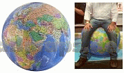
... ist ein detaillierter Globus


Die Welt ist ein Geschenkpapier


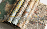
Wandkarten fürs Büro und fürs Heim
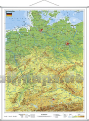

Puzzle-Spiele
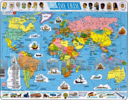
Landkartenpuzzles und viele andere Motive


Schicke Taschen


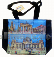
Die Welt aus dem All
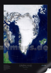
Dekorative Satellitenbild-Poster in gestochen scharfer Auflösung!


Riesengloben zum Aufpusten
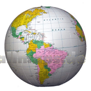
So entdecken Kinder die Welt.